Virtual Gallery of Historic New Brunswick
Early Paintings, Prints, and Photographs of New Brunswick, 1750-1920
Click on the thumbnail images to see the full-size image
 "A View of the Plundering and Burning of Grimross", 1758, monochrome watercolour by Lt. Thomas Davies. "Grimross" was a French village on the site of present-day Gagetown on the St. John River. The village of some 300 inhabitants was sacked and burned to the ground by a British force from Fort Frederick led by Colonel Robert Monckton in October 1758 during the Seven Years Wars between France and England. Credit: National Gallery of Canada/No. 6270.
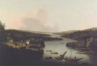 "A View of Miramichi", 1760, oil painting by Francis Swaine after a view by Captain Hervey Smyth. Credit: National Gallery of Canada/No. 4976.
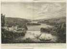 "A View of Miramichi, a French settlement in the Gulf of St. Lawrence, destroyed by Brigadier Murray detached by General Wolfe for that purpose, from the Bay of Gaspe", 1760. Engraved by Paul Sandby and retouched by P. Benazech, after a sketch by Captain Hervey Smyth. Based on the same sketch as the painting above. Credit: New York Public Library/Emmett Collection/EM4433.
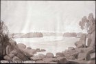
 "The North Point of Grand Manan Island in the Bay of Fundy", 1780, aquatint with etching by Joseph F. W. Des Barres, published in The American Neptune. The view is from two leagues distant, bearing east by northeast. Credit: Library of Congress/LC-USZ62-46054.
 "A View of Campobello Island at the entrance of Passamaquoddy Bay", 1780, aquatint with etching by Joseph F. W. Des Barres, published in The American Neptune. Credit: Library of Congress/LC-USZ62-31951.
 "A View of the Great Falls (Grand Falls) on the Height of Lands on the River St. John", ca. 1782, watercolour by Lt. Henry Holland. Credit: Library and Archives Canada/ Peter Winkworth Collection/C-149840.
 "View of the Great Falls (Grand Falls) of the Saint John", 29 July 1807, grey and green wash over pencil by George Heriot. Credit: Library and Archives Canada/C-002898.
 "St. John River", ca. 1807, watercolour over pencil by George Heriot. Credit: Library and Archives Canada/C-012771.
 "Presqu'isle, St. John River", 20 July 1807, blue, grey and black wash over pencil by George Heriot. Credit: Library and Archives Canada/C-012724.
 "View on the River St. John near the Poquioq [Pokiok]", 23 July 1807, brown wash by George Heriot. Credit: Royal Ontario Museum/953.132.2.
 "Fall of the Poquioq [Pokiok] River, St. John River", ca. 1807, brown wash over pencil by George Heriot. Credit: Royal Ontario Museum/953.132.29.
 "Chief Justice George Duncan Ludlow's home on the St. John River at Springhill, five miles above Fredericton", 1807, by George Heriot. Credit: Royal Ontario Museum/950.31.
 "View on the River St. John from the deck of a Steamboat", 1817, by John E. Woolford, published in John Elliott Woolford, Sketches Of Nova Scotia (1817). Launched in 1816, the General Smyth was the first steamboat in New Brunswick. Credit: Nova Scotia Museum/78.45.117.
 "On the River St. John from the Northeast", 1817, by John E. Woolford, published in John Elliott Woolford, Sketches Of Nova Scotia (1817). Credit: Nova Scotia Museum/78.45.113.
 "Falls on the River St. John from the Southeast", 1817, by John E. Woolford, published in John Elliott Woolford, Sketches Of Nova Scotia (1817). Credit: Nova Scotia Museum/78.45.114.
 "Inscription on the New Monument erected at the Source of the St. Croix on the 31st of July 1817", lithograph by Louis Haghe after a sketch by Col. Joseph Bouchette, published in Joseph Bouchette, The British Dominions (London 1831). The monument marked the source of the St. Croix River for purposes of determining the boundary between New Brunswick and Maine--the boundary between the United States and British North America. The surveying group with Bouchette and John Johnson of the U. S. was performing work for the boundary commission created by the Treaty of Ghent which had ended the War of 1812. Note the iron hoop on a beech tree to the left of the new monument--it was an old marker fixed in 1797 by surveyors Samuel Titcomb and John Harris. Credit: Robert Fisher.
![R Thresher [1769] Beaubears Island - John & Alexander Fraser establishment - GH 996.9.1.jpg](Images/NBGallery/Thumbs/R Thresher [1769] Beaubears Island - John & Alexander Fraser establishment - GH 996.9.1.jpg) "Beaubear's Island, Miramichi The Commercial Establishment of John and Alexander Fraser and Co.", ca. 1825, oil painting by R. Thresher. Credit: New Brunswick Heritage Branch/GH 996.9.1.
"Beaubear's Island, Miramichi The Commercial Establishment of John and Alexander Fraser and Co.", ca. 1825, oil painting by R. Thresher. Credit: New Brunswick Heritage Branch/GH 996.9.1.
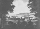
 "Mars Hill", 1832, watercolour by Joseph Bouchette. Mars Hill was a pivotal reference point in the boundary dispute between New Brunswick and Maine in the 1820s. Forty miles from the source of the St. Croix River (not far from Woodstock), the British argued that it marked the "highlands" referred to in the Treaty of Ghent, at which the border line drawn due north from the source of the St. Croix should terminate. Credit: Library and Archives Canada/C-047011.
 "Erecting the Mill dam at Stanley", August 1834. Coloured lithograph by S. Russell (Day and Haghe Lithographers) after Edward N. Kendall. Published in Sketches in New Brunswick showing the Nature, & Description of the Land in the Tract Purchase by the N.B. & N.S. Land Co. in the Year 1833 (London: Ackermann, 1836). Credit: Library and Archives Canada/C-021959.
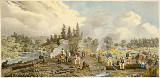
 "Process of Clearing the town plot of Stanley", October 1834. Coloured lithograph by S. Russell (Day and Haghe Lithographers) after William P. Kay. Published in Sketches in New Brunswick showing the Nature, & Description of the Land in the Tract Purchase by the N.B. & N.S. Land Co. in the Year 1833 (London: Ackermann, 1836). Credit: Library and Archives Canada/C-000017.
 "Tavern built of logs at Stanley", June 1835. Coloured lithograph by S. Russell (Day and Haghe Lithographers) after Philip Harry. Published in Sketches in New Brunswick showing the Nature, & Description of the Land in the Tract Purchase by the N.B. & N.S. Land Co. in the Year 1833 (London: Ackermann, 1836). Credit: Library and Archives Canada/C-004089.
 "General View of Stanley from the Road", August 1835. Coloured lithograph by S. Russell (Day and Haghe Lithographers) after Philip Harry. Published in Sketches in New Brunswick showing the Nature, & Description of the Land in the Tract Purchase by the N.B. & N.S. Land Co. in the Year 1833 (London: Ackermann, 1836). Credit: Library and Archives Canada/C-007163.
 "The Mill at Stanley", August 1835. Coloured lithograph by S. Russell (Day and Haghe Lithographers) after Philip Harry. Published in Sketches in New Brunswick showing the Nature, & Description of the Land in the Tract Purchase by the N.B. & N.S. Land Co. in the Year 1833 (London: Ackermann, 1836). Credit: Library and Archives Canada/C-007163.
 "Salmon fishing by torchlight", ca. 1836, watercolour by Sir Richard George Augustus Levinge. Credit: Library and Archives Canada/C-035960.
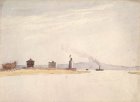
 "View of the Town of St. Andrew's with its magnificent Harbour and Bay", ca. 1840. Coloured lithograph by William Day (Day and Son Lithographers) after a sketch by Frederick Wells. Credit: Library and Archives Canada/C-016386.
 "Looking across the St. John River from Woodstock", 25 or 26 June 1840, watercolour over pencil by Alexander C. Mercer. The view is from a window in Mrs. Grover's tavern in Woodstock. Credit: Library and Archives Canada/C-013790.
 "St. John River at Woodstock", 26 June 1840, watercolour over pencil by Alexander C. Mercer. The view is "from the shore under the bank at Woodstock, looking down the St. John's. Alongside is one of the track-boats used to carry goods between Fredericton and Woodstock". Credit: Library and Archives Canada/C-035988.
 River at Grand Falls - LAC C-013796.jpg) "Junction of the Fall (Little) River at Grand Falls", 29 June 1840, watercolour over pencil by Alexander C. Mercer. The view is from Ryan's Tavern, Grand Falls: "In front is the junction of the Fall River with the St. John's into which it comes exactly at the head of the Falls". An inscription that is crossed out states that on the right is part of Sir John Calder's cottage. Credit: Library and Archives Canada/C-013796.
"Junction of the Fall (Little) River at Grand Falls", 29 June 1840, watercolour over pencil by Alexander C. Mercer. The view is from Ryan's Tavern, Grand Falls: "In front is the junction of the Fall River with the St. John's into which it comes exactly at the head of the Falls". An inscription that is crossed out states that on the right is part of Sir John Calder's cottage. Credit: Library and Archives Canada/C-013796.
 "View at Grand Falls from the verandah of Ryan's Tavern", 29 June 1840, watercolour over pencil by Alexander C. Mercer. Credit: Library and Archives Canada/C-013793.
 "Eastern Entrance to the Harbour of St. Andrew's", 18 July 1841, watercolour over pencil by Alexander C. Mercer. Deer Island is in the distance and the steamer Nova Scotia (Captain Reid) is coming in to the harbour. Credit: Library and Archives Canada/C-002899.
![Philip John Bainbrigge [1836-1842] Junction of the Madawaska and St John wc LAC C011852k.jpg](Images/NBGallery/Thumbs/Philip John Bainbrigge [1836-1842] Junction of the Madawaska and St John wc LAC C011852k.jpg) "Junction of the Madawaska and St. John Rivers", [ca. 1836-1842], watercolour over pencil by Philip John Bainbrigge. Credit: Library and Archives Canada/C-011852.
"Junction of the Madawaska and St. John Rivers", [ca. 1836-1842], watercolour over pencil by Philip John Bainbrigge. Credit: Library and Archives Canada/C-011852.
![Philip John Bainbrigge [1842] Block House Junction of the Madawaska and St John wc LAC C000918.jpg](Images/NBGallery/Thumbs/Philip John Bainbrigge [1842] Block House Junction of the Madawaska and St John wc LAC C000918.jpg) "Block House at the Junction of the Madawaska and St. John Rivers", 1842, watercolour over pencil by Philip John Bainbrigge. Credit: Library and Archives Canada/C-000918.
"Block House at the Junction of the Madawaska and St. John Rivers", 1842, watercolour over pencil by Philip John Bainbrigge. Credit: Library and Archives Canada/C-000918.
 "Sleighing in New Brunswick", 1843, watercolour over pencil by Sir Richard George Augustus Levinge. Credit: National Gallery of Canada/No. 9933.
 "Grand Falls, St. John River", 1843, watercolour over pencil by Lt. Henry James Warre. Credit: Library and Archives Canada/C-031258.
 "76th Regiment cod fishing near St. Andrew's", 1854, watercolour by Lt. James C. Clarke. Credit: Library and Archives Canada/C-039744
 "Ambush capture of deserters at Bryant's Bridge near St. Andrew's", 1854, watercolour by Lt. James C. Clarke. Credit: Library and Archives Canada/C-043156
 "Detachment of the 76th Regiment putting out a fire in St. Andrew's", 1854, watercolour by Lt. James C. Clarke. Credit: Library and Archives Canada/C-039749.
 "Detachment of the 76th Regiment in pursuit of deserters near St. Andrew's", 1854, watercolour by Lt. James C. Clarke. Credit: Library and Archives Canada/C-039748.
![W J Peirce and [Charles A] Barry 28 Mar 1857 Ballou's Pictorial Bathurst on the Chaleur Bay.jpg](Images/NBGallery/Thumbs/W J Peirce and [Charles A] Barry 28 Mar 1857 Ballou's Pictorial Bathurst on the Chaleur Bay.jpg) "Bathurst on the Chaleur Bay", 1857. Wood engraving by W. J. Peirce after a drawing by [Charles A.] Barry, published in Ballou's Pictorial (Boston Mass.), 28 March 1857. The publication correctly places Bathurst on the Chaleur Bay but inaccurately identifies the province as Newfoundland instead of New Brunswick. Credit: Rob Fisher.
"Bathurst on the Chaleur Bay", 1857. Wood engraving by W. J. Peirce after a drawing by [Charles A.] Barry, published in Ballou's Pictorial (Boston Mass.), 28 March 1857. The publication correctly places Bathurst on the Chaleur Bay but inaccurately identifies the province as Newfoundland instead of New Brunswick. Credit: Rob Fisher.
![W J Peirce and [Charles A] Barry 28 Mar 1857 Ballou's Pictorial Grand Falls on the Nipisiguit river](Images/NBGallery/Thumbs/W J Peirce and [Charles A] Barry 28 Mar 1857 Ballou's Pictorial Grand Falls on the Nipisiguit river.jpg) "Grand Falls on the Nipisiguit River", 1857. Wood engraving by W. J. Peirce after a drawing by [Charles A.] Barry, published in Ballou's Pictorial (Boston, Mass.), 28 March 1857. Credit: Rob Fisher.
"Grand Falls on the Nipisiguit River", 1857. Wood engraving by W. J. Peirce after a drawing by [Charles A.] Barry, published in Ballou's Pictorial (Boston, Mass.), 28 March 1857. Credit: Rob Fisher.
 "Lumbering in New Brunswick - Lumbermen at work in the forest". Engraving by Johannes Oertel, published in the Illustrated London News, 23 August 1858. Credit: Rob Fisher.
 "Morning at the mid landing", Nipisiguit River, 1857. Coloured lithograph by F. Jones (Day and Son Lithographers) after William Hickman. Published in Sketches on the Nipisaguit, A River of New Brunswick, British North America (Halifax: John B. Strong, 1860). Credit: Library and Archives Canada/C-112115.
 "Town of Bathurst", ca. 1860. Coloured lithograph by F. Jones (Day and Son Lithographers) after William Hickman. Published in Sketches on the Nipisaguit, A River of New Brunswick, British North America (Halifax: John B. Strong, 1860). Credit: Library and Archives Canada/C-017505.
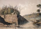
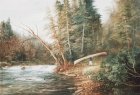
 "Scene on the Restigouche River near Henderson Camp", ca. 1857-1863, watercolour by William Hickman. Credit: Library and Archives Canada/Peter Winkworth collection/C-150567.
 "St. Andrew's Harbour and Bay", 1862, engraving by A. P. Leitch, published in the Illustrated London News, 1 February 1862. Credit: public domain.
 "How the Guards crossed New Brunswick", 1862, pencil sketch by Colonel Henry Hope Crealock. Credit: Library and Archives Canada/Peter Winkworth collection/ e001201116.
 "Sunset in Winter", 1862, watercolour and gouache over pencil by Colonel Henry Hope Crealock. Credit: Library and Archives Canada/Peter Winkworth collection/ e001201087.
 "Caribou Hunting in New Brunswick - The Start", 1863, anonymous artist and engraver, published in the Illustrated London News, 18 January 1863. The print, subsequently hand-coloured, appeared originally in the Illustrated London News along side the following print which shows the grisly conclusion of the hunt. Credit: public domain.
 "Caribou Hunting in New Brunswick - In at the Death", 1863, anonymous artist and engraver, published in the Illustrated London News, 18 January 1863. Credit: public domain.
 "Timber Booms on the St. John River", 1866, anonymous artist and engraver, published in the Illustrated London News, 7 April 1866. Timber booms such as this would have been a common sight on the St. John River in the 19th century. Credit: Rob Fisher.
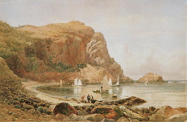
 "Whale Cove, Grand Manan Island", 1871. Engraving by Robert Hinshelwood after a painting by William Hart, published in the Ladies Repository of Cincinnati. Note the incorrect spelling--Grand "Mannan"--on the print. Credit: Rob Fisher.
 "View looking up the river St. John 3 miles above Grand Falls", 1872, engraver anonymous, after a photograph by George T. Taylor, published in the Canadain Illustrated News, 16 March 1872. Credit: Public Domain.
 "Mount Allison Wesleyan College and Academies, Sackville", 1872, engraver anonymous, after a sketch by Professor Gray, published in Canadian Illustrated News, 3 August 1872, Vol.VI, No.5, p.68. Credit: Library and Archives Canada.
 "Mill at French Fort Cove, Miramichi", 1872, engraver and artist anonymous, published in Canadian Illustrated News, 10 August 1872, Vol.VI, No.6, p.85. Credit: Library and Archives Canada.
 "View up the Miramichi River from Newcastle", 1872, engraved by Eugene Haberer from a sketch by William Ogle Carlisle, published in Canadian Illustrated News, 21 December 1872, Vol.VI, No.25, p.388. Credit: Library and Archives Canada.
 "Green Head, St. John River", before 1874, photograph by James McClure (albumen silver print). Credit: National Gallery of Canada/No. 32199.7.
 "Loch Lomond near Saint John", before 1874, photograph by James McClure (albumen silver print). Credit: National Gallery of Canada/No. 32199.6.
 "The Grand Cross, Gull Cliffs, Grand Manan Island", 1878, watercolour over pencil by Lucius R. O'Brien. Credit: National Gallery of Canada/No. 36809.
 "Eel Brook Bay, Grand Manan Island", 1880, watercolour over pencil by Lucius R. O'Brien. Credit: National Gallery of Canada/No. 18534.
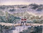
 Camping at the Tobique Narrows, ca. 1880, watercolour by John Henry Phair of Fredericton. Credit: Fred Bradley private collection.
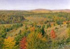
 New Brunswick, unidentified location, ca. 1880, watercolour by John Henry Phair of Fredericton. Credit: Fred Bradley private collection.
![William G R Hind [ca 1870s] On the coast of St John oil LACC096621.jpg](Images/NBGallery/Thumbs/William G R Hind [ca 1870s] On the coast of St John oil LACC096621.jpg) "On the Coast of Saint John [Bay of Fundy]", ca. 1870-1880, oil painting by William G. R. Hind. Hind moved to New Brunswick in the 1870s where he was employed by the Intercolonial Railway. He died in Sussex in 1889. Credit: Library and Archives Canada/C-096621.
"On the Coast of Saint John [Bay of Fundy]", ca. 1870-1880, oil painting by William G. R. Hind. Hind moved to New Brunswick in the 1870s where he was employed by the Intercolonial Railway. He died in Sussex in 1889. Credit: Library and Archives Canada/C-096621.
 "Harvesting Hay, Sussex, New Brunswick", ca. 1880, oil painting by William G. R. Hind. Credit: Library and Archives Canada/C-103003.
 "New Brunswick Landscape", ca. 1879-1889, watercolour and gouache with gum arabic by William G. R. Hind. Credit: National Gallery of Canada/No. 30195.
 "Junction of the Tay and Nashwaak rivers", 1882. Engraver and artist unknown, published in George Monro Grant, Picturesque Canada (Toronto 1882), vol. 2, p.760b. Credit: Public Domain.
 "Portage", 1888, oil painting by George T. Taylor. Credit: Beaverbrook Gallery/1969.26.
 "Grand Falls, St. John River", 1890, watercolour over pencil by Lucius R. O'Brien. Credit: National Gallery of Canada/No. 7757.
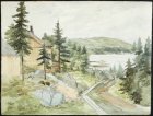 "View from the Chamaris Hotel verandah", September 1891, watercolour over pencil by [Ava] Capel. Credit: Library and Archives Canada/Peter Winkworth collection/C-150438.
 "Main Street, Woodstock", ca. 1900, photograph by Isaac Erb. Credit: Provincial Archives of New Brunswick/P11-84.
 "Town of Woodstock from across the St. John River", ca. 1903, photograph by H. F. Albright. Credit: Provincial Archives of New Brunswick/P530-13.
![R B Miller [ca 1910] A typical camp scene in New Brunswick NYPL Pageant of America Collection.jpg](Images/NBGallery/Thumbs/R B Miller [ca 1910] A typical camp scene in New Brunswick NYPL Pageant of America Collection.jpg) "A typical camp scene in New Brunswick", [ca. 1910], photograph by R. B. Miller. Credit: New York Public Library/Pageant of America Collection.
"A typical camp scene in New Brunswick", [ca. 1910], photograph by R. B. Miller. Credit: New York Public Library/Pageant of America Collection.
![R B Miller [ca 1910] Douglas Booms above Fredericton a sorting and rafting gap NYPL Pageant of America collection.jpg](Images/NBGallery/Thumbs/R B Miller [ca 1910] Douglas Booms above Fredericton a sorting and rafting gap NYPL Pageant of America collection.jpg) "Douglas Booms above Fredericton, a sorting and rafting gap", [ca. 1910], photograph by R. B. Miller. The Douglas Booms were located at Springhill, close by were the rival Glasier Booms. Credit: New York Public Library/Pageant of America collection.
"Douglas Booms above Fredericton, a sorting and rafting gap", [ca. 1910], photograph by R. B. Miller. The Douglas Booms were located at Springhill, close by were the rival Glasier Booms. Credit: New York Public Library/Pageant of America collection.
![R B Miller [ca 1910] Putting floaters on top of a joint St. John River Douglas Boom NYPL Pageant of America Collection.jpg](Images/NBGallery/Thumbs/R B Miller [ca 1910] Putting floaters on top of a joint St. John River Douglas Boom NYPL Pageant of America Collection.jpg) "Putting floaters on top of a joint, St. John River, Douglas Boom", [ca. 1910], photograph by R. B. Miller. Credit: New York Public Library/Pageant of America collection.
"Putting floaters on top of a joint, St. John River, Douglas Boom", [ca. 1910], photograph by R. B. Miller. Credit: New York Public Library/Pageant of America collection.
![unknown [nd ca 1910] A jam at Grand Falls St John River NYPL Pageant of America Collection.jpg](Images/NBGallery/Thumbs/unknown [nd ca 1910] A jam at Grand Falls St John River NYPL Pageant of America Collection.jpg) "A Jam at Grand Falls, St. John River", [ca. 1910], photograph by R. B. Miller. Credit: New York Public Library/Pageant of America collection.
"A Jam at Grand Falls, St. John River", [ca. 1910], photograph by R. B. Miller. Credit: New York Public Library/Pageant of America collection.

Copyright © Rob Fisher 2002-2020 [Text only]
 "A View of the Plundering and Burning of Grimross", 1758, monochrome watercolour by Lt. Thomas Davies. "Grimross" was a French village on the site of present-day Gagetown on the St. John River. The village of some 300 inhabitants was sacked and burned to the ground by a British force from Fort Frederick led by Colonel Robert Monckton in October 1758 during the Seven Years Wars between France and England. Credit: National Gallery of Canada/No. 6270.


![R Thresher [1769] Beaubears Island - John & Alexander Fraser establishment - GH 996.9.1.jpg](Images/NBGallery/R Thresher [1769] Beaubears Island - John & Alexander Fraser establishment - GH 996.9.1.jpg)


 River at Grand Falls - LAC C-013796.jpg)


![Philip John Bainbrigge [1836-1842] Junction of the Madawaska and St John wc LAC C011852k.jpg](Images/NBGallery/Philip John Bainbrigge [1836-1842] Junction of the Madawaska and St John wc LAC C011852k.jpg)
![Philip John Bainbrigge [1842] Block House Junction of the Madawaska and St John wc LAC C000918.jpg](Images/NBGallery/Philip John Bainbrigge [1842] Block House Junction of the Madawaska and St John wc LAC C000918.jpg)


![W J Peirce and [Charles A] Barry 28 Mar 1857 Ballou's Pictorial Bathurst on the Chaleur Bay.jpg](Images/NBGallery/W J Peirce and [Charles A] Barry 28 Mar 1857 Ballou's Pictorial Bathurst on the Chaleur Bay.jpg)
![W J Peirce and [Charles A] Barry 28 Mar 1857 Ballou's Pictorial Grand Falls on the Nipisiguit river](Images/NBGallery/W J Peirce and [Charles A] Barry 28 Mar 1857 Ballou's Pictorial Grand Falls on the Nipisiguit river.jpg)


![William G R Hind [ca 1870s] On the coast of St John oil LACC096621.jpg](Images/NBGallery/William G R Hind [ca 1870s] On the coast of St John oil LACC096621.jpg)


![R B Miller [ca 1910] A typical camp scene in New Brunswick NYPL Pageant of America Collection.jpg](Images/NBGallery/R B Miller [ca 1910] A typical camp scene in New Brunswick NYPL Pageant of America Collection.jpg)
![R B Miller [ca 1910] Douglas Booms above Fredericton a sorting and rafting gap NYPL Pageant of America collection.jpg](Images/NBGallery/R B Miller [ca 1910] Douglas Booms above Fredericton a sorting and rafting gap NYPL Pageant of America collection.jpg)
![R B Miller [ca 1910] Putting floaters on top of a joint St. John River Douglas Boom NYPL Pageant of America Collection.jpg](Images/NBGallery/R B Miller [ca 1910] Putting floaters on top of a joint St. John River Douglas Boom NYPL Pageant of America Collection.jpg)
![unknown [nd ca 1910] A jam at Grand Falls St John River NYPL Pageant of America Collection.jpg](Images/NBGallery/unknown [nd ca 1910] A jam at Grand Falls St John River NYPL Pageant of America Collection.jpg)